Voyage planning is a key element of Bridge Resource Management (BRM) forming the foundation the bridge team will use to ensure the vessel’s safe transit along its intended route. A voyage plan (or passage plan) is a comprehensive, berth to berth guide, developed and used by a vessel’s bridge team to determine the most favorable route, to identify potential problems or hazards along the route, and to adopt bridge management practices to ensure the vessel’s safe passage. During passage planning, portions of a voyage that have the potential to pose the greatest risk should receive additional review, and the limits and conditions for undertaking those portions of the voyage set in advance.
As the phase in period for ECDIS use has been completed in July 2018, all applicable vessels should use ECDIS systems for planning, moving from traditional paper chart navigation. Port state control inspections also started to be detailed and extended on passage plan review, a factor which adds more difficulty and pressure to Bridge officers and Masters.
Prior proceeding to planning, it has to be ensured that all initial actions and setup/start up information has been already incorporated to ECDIS. Special attention should be given when entering Vessel’s information for dimensions and the Consistent Common Reference Point which is defined as “a location on own ship, to which all horizontal measurements such as target range, bearing, relative course, relative speed, closest point of approach (CPA) or time to closest point of approach (TCPA) are referenced, typically the conning position of the bridge.”
[smlsubform prepend=”GET THE SAFETY4SEA IN YOUR INBOX!” showname=false emailtxt=”” emailholder=”Enter your email address” showsubmit=true submittxt=”Submit” jsthanks=false thankyou=”Thank you for subscribing to our mailing list”]
SOLAS chapter V (Annex 24 and Annex 25) provides the legislative guidance for Passage planning in shipping sector. In accordance with this guidance, there are four stages for planning a voyage:
- Appraising all relevant information
- Planning the intended voyage
- Executing the plan taking account of prevailing conditions
- Monitoring the vessel’s progress against the plan continuously
In this article we will refer only to the two first stages, Appraising information and Planning the intended voyage.
Appraisal
This stage of plan is aimed to identify that the required electronic charts are available and corrected up-to-date and all other relevant publications (paper or electronic) are available and up to date.
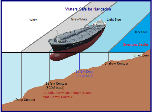
Safety contours should be established and information relating to weather, current, tides, chart datum, draft, speed, environmental limits, air draft, squat and general hazards, such as high traffic concentrations, should be prepared and made available.
The concept of safety contours is a key function specific to electronic charts and the whole safety of the passage is dependent on this information being correct. So, if a navigator fails to set this correctly, then an incident might occur.
The safety contour marks distinguish between ‘safe’ and ‘unsafe’ water. If the navigator does not specify a safety contour, this will default to 30m. When the safety contour is not displayed to the specified value set by the navigator, then the safety contour is shown to the next deeper contour as per the default layers in the electronic charts.
During route planning, an indication will be made if the route is planned to cross the ship’s safety contour. At the time of route monitoring, ECDIS should give an alarm if, within a specified time set by the navigator, own ship is likely to cross the safety contour.
The division between ‘safe’ and ‘unsafe’ water is highlighted by chart coloring (usually blue color used to indicate unsafe area and white or grey for safe area).
Safety contour should be calculated based on safety depth. Safety depth is the sum of Maximum Draft (static)+UKC (Company’s Policy)+Squat(Maximum)-Height of Tide. As safety contour produces alarm mariners should be very careful to the value that they select. The safest way is to choose a safety contour equal or greater to safety depth.
After setting the safety contour, the next task is to set up a safety domain. IMO specifications require ECDIS to trigger alarms in the following circumstances:
- If, within a specified time set by the mariner, the vessel will cross the safety contour
- If, within a specified time set by the mariner, the vessel will cross the boundary of a prohibited area or of a geographical area for which special conditions exist. (no go areas, restricted or prohibited areas, naval exercise areas etc.)
- When the specified cross track limit for deviation from the planned route is exceeded (distance to be determined by mariner)
- If, continuing on its present course and over a specified time or distance set by the mariner, the ship will pass closer than a user-specified distance from a danger (eg obstruction wreck or rock) that is shallower than the mariner’s contour or an aid-to navigation.
To achieve the above, mariners should specify a safety domain for the vessel, effectively contained by the following parameters:
- In depth, by the safety contour and safety depth
- In forward extent, by the look-ahead time or look-ahead range
- In lateral closeness by a specified distance.
The Anti-Grounding Cone (may also be known as the Safety Frame or other name dependent upon the manufacturer) is intended for setting the size of the area that will be used for the chart data analysis and for the generation of the Anti-Grounding alarms, Area Alerts and Navigational Alarms.
The trigger points for Alarms and Warnings are defined by an Anti-Grounding Cone projected Ahead, Port and Starboard of the vessel. The size of the Anti-Grounding Cone will depend on the ECDIS system in use, as well as the size, maneuverability and speed of the vessel. Once a danger has been picked up in the Anti-Grounding Cone, it will be necessary for the vessel to avoid it and this delay / time to maneuver must be taken into account when setting up. The safety domain requires the navigator to input the vessel / voyage specific parameters and so this must be done at this stage. Master should be consulted to determine these parameters prior installed.
Planning
After the appraisal stage, planning officer now begins the track planning. It is essential that the ‘built in automatic check’ function is used throughout planning stages, however it must be remembered that effectiveness of the automatic check system relies on the accuracy of the safety parameters set by the user.
Passage planning on an ECDIS requires almost the same procedures as for a paper chart and the navigator must follow the same “best practice” guidelines as per the Bridge Procedures Guide. However, with ECDIS, the process is complicated by the fact that the navigator needs to know what information is already incorporated into the ECDIS and what is not and this is where a weakness of ECDIS is exposed.
Reference should be made to the traditional passage planning documents (printed or electronic), such as NtMs,tide & current tables, Lists of Lights, sailing directions, NAVTEXT etc. relevant to the proposed passage.
Once the navigator has all the relevant documentation in hand, the plan can commence and the first thing to check is whether waypoints for that passage already exist in the ECDIS database. If so, it can be uploaded for re-use and, by running an initial check, the ECDIS will verify if the plan is safe for the dynamic parameters previously set.
As well as alerting the navigator to any parts of the plan that are outside the safety domain parameters, the ECDIS will also alert the navigator to charted features of relevance on the passage, such as traffic separation zones, restricted areas, anchorages etc. How alerts are presented to the navigator are dependent on the manufacturer with the best automatically jumping to the problem area and others providing a simple dropdown list. If no pre-loaded waypoint list exists for passage, then navigator will have to start from creating waypoints.
The main problem that traditional mariners find with this is the small screen size which makes it difficult to obtain outline overview obtained from a small scale paper chart. However, in practice, the advantage of ECDIS is that by putting in departure and arrival points, any obstructions will be identified and the navigator can then move waypoints and re-check the outline route.
For longer ocean passages, the ECDIS is really useful since it can instantaneously offer a great circle or Rhumb line route or a combination of both, thus saving much tedious plotting.
Once a viable outline passage has been established, it is then essential to check the whole route in detail using the zooming and scrolling facilities. This is easier and less error-prone than drawing course lines on a series of passage charts of differing scales.
However, it is essential that this process is done with extreme care, because many chart features -such as submarine cables- are hidden on the different layers of the ENC and essential detailed information -such as notes pertaining to precautionary areas- needs to be accessed and analyzed for relevance by means of clicking on the ! symbol to obtain the “pick report” relating to the feature.
Every planned passage plan should be saved in both ECDIS systems (primary and secondary) in order to be ready for use in case of equipment failure.
Master should review and approve the plan and all officers assigned with duties of navigational watch to review and sign it accordingly.
SQE has developed a sample of toolbox meeting in order to be used as guidance onboard












Refer to the Nautical Institutes publication
Bridge Team Management
Second edition
Captain AJ Swift FNI and T J Bailey FNI
An industry standard for passage planning,
the guide covers practical coastal and estuarial
navigation and bridge organisation for use
on both paper and electronic charts. There
is detailed information on preparing a navigational plan and
navigator’s notebook and ways to monitor progress in ‘safe’ water.
Other chapters cover team management, error chains, casualties
and causes, bridge organisation, passage appraisal, situational
awareness and executing the plan.