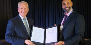
Demonstrating multilateral cooperation to improve navigational safety in the Straits of Malacca and Singapore (SOMS), the Phase Two of a Joint Hydrographic Survey was formally launched via a Memorandum of Understanding (MoU) signed at the 10th Co-operation Forum held on 2-3 October, at Kota Kinabalu, Malaysia, among Malaysia, Singapore and Indonesia.
Phase Two, which is a continuation from Phase One, will cover the remaining areas of the Traffic Separation Scheme (TSS) within the SOMS which are shallower than 30m. The data obtained from the survey would be used to produce up-to-date, large-scale nautical charts for safe navigation and better voyage planning in the SOMS, one of the busiest waterways in the world. It would also be put to good use by the industry and academia for research in relevant areas.
Signatories to the MoU included Mr Andrew Tan, Chief Executive, Maritime and Port Authority of Singapore, Mr Nyoman Sukayadnya, on behalf of Director-General of Sea Transportation, Director of Navigation, Dr Harjo Susmoro, Chief of Indonesian Hydrographic Centre, Mr Tatsuhiko Miyazaki, President, Malacca Strait Council of Japan and Dato’ Hj. Baharin Bin Dato’ Abdul Hamid, Director-General of Malaysia Marine Department.
“The Joint Hydrographic Survey for the SOMS will allow navigational charts to be updated with the latest nautical information and help improve navigational safety in one of the world’s most well-used waterways. It reflects the joint efforts of the three littoral states in promoting safety of navigation in the Straits,” said Mr Andrew Tan, Chief Executive of MPA.


