The Department of Environment and Natural Resources (DENR) of Philippines has released a statement claiming that with the help of BRP Hydrographer Ventura, they may have detected the possible site where the sunk vessel Princess Empress is located.
Princess Empress, was motor tanker sank on February 27th due to engine overheating, causing a major oil spill in Mindoro, Philippines. The vessel has not been detected so that any further damage can be contained.
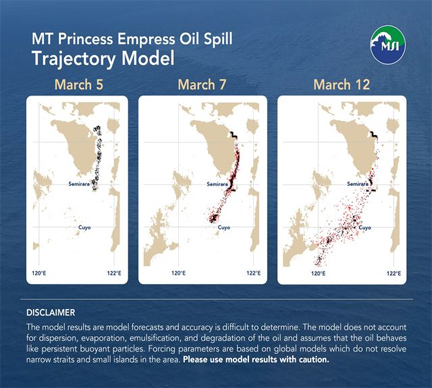
The most probable site of the ship is about 1,200 feet or approximately 400 meters below sea level. It is located about Northeast of Pola, Oriental Mindoro but it is believed to have moved Southeast from its last known position where it completely submerged. This will, however, require verification which will be in the form of deployment of a remotely operated vehicle (ROV) which will allow them complete visualization. The authorities are currently preparing to access an ROV in order to fully determine where the vessel actually is and to completely model the way the oil will be spilling from the vessel.
The DENR has employed three parallel workstreams in response to the oil spill:
- Disaster forensics in cooperation with NAMRIA as an attached agency of the DENR and the University of the Philippines-Marine Science Institute (UP-MSI), in support of the Philippine Coast Guard.
- Clean up, mitigation, and remediation which involves a multi-agency effort including national government agencies such as DSWD, DOLE, DILG, and DOH because this involves the protection of communities and ecosystems.
- Actual protection activities that we need to undertake. These habitats, ecosystems, and the communities themselves require anticipatory action, protection, and regeneration where possible. We are working with the local communities, UP-MSI, academe, and civil society.
According to the Marine Science Institute, University of Philippines, among the coastal sites that may be at risk are several marine protected areas (MPAs) including but not limited to the reefs in Bulalacao, Oriental Mindoro, amounting to some 1,100 ha of coral reefs. Significant seagrass beds are present in several areas, including the coastal barangays of Pola, Mansalay, Bulalacao in Oriental Mindoro. Caluya Island in Northwestern Antique, which has a high possibility of being affected based on the oil spill trajectory model, also has significant areas of coral reefs (2,900 ha), mangroves (350 ha), and seagrass meadows (850 ha).

DENR Environmental Management Bureau MIMAROPA continues its cleanup operations using locally available oil-absorbent materials. EMB is currently installing provisional spill booms made of cogon and sawali. These barriers are precautionary measures to prevent the oil spill from reaching the beach and mangrove areas of Pola, Oriental Mindoro.
The Philippine Coast Guard also continues operations to clean the oil spill with personnel collecting 92 sacks of oiled debris, sea grasses, and used oil absorbent pads at Sitio Bagong Silang, Barangay Buhay na Tubig in Pola, Oriental Mindoro on March 7th 2023.
LOOK: @coastguardph personnel collected 92 SACKS of oiled debris, sea grasses, and used oil absorbent pads during the coastal clean-up at Sitio Bagong Silang, Barangay Buhay na Tubig in Pola, Oriental Mindoro, yesterday, 07 March 2023. pic.twitter.com/ppLFw3HJ9w
— Philippine Coast Guard (@coastguardph) March 8, 2023


