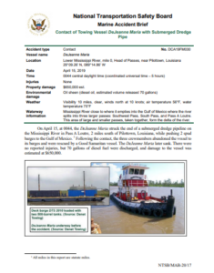
The NTSB issued an investigation report on the contact of the towing vessel Dejeanne maria with a submerged dredge pipe on the Lower Mississippi River, in April 2019. The investigation highlighted that the last bathymetric survey did not detect the hazard, which had been brought to just below the surface due to an unsuccessful lift the day before.
The incident
On April 15, at 0044, the DeJeanne Maria struck the end of a submerged dredge pipeline on the Mississippi River in Pass A Loutre, 2 miles south of Pilottown, Louisiana, while pushing 2 spud barges to the Gulf of Mexico.
Following the contact, the three crew members abandoned the vessel to its barges and were rescued by a Good Samaritan vessel. The DeJeanne Maria later sank.
There were no reported injuries, but 70 gallons of diesel fuel were discharged, while damage to the vessel was estimated at $650,000.
Probable cause
The National Transportation Safety Board determines that the probable cause of the contact between the towing vessel DeJeanne Maria and a submerged dredge pipeline end was the last bathymetric survey not detecting the hazard, which had been brought to just below the surface due to an unsuccessful lift the day before.
Analysis
Three water depth surveys were conducted in the area of the end of the submerged pipeline: in October 2018 after the pipeline was originally laid, in December 2018 when the R S Weeks disconnected to temporarily relocate, and again on April 14, 2019, following the unsuccessful attempt to lift the pipe from the river bottom to reconnect to the R S Weeks.
The DeJeanne Maria, with a draft of about 6 feet, was transiting through Pass A Loutre in the area only a day after the April 14 survey. That survey showed water depths of 6.8–10 ft, which was adequate for the DeJeanne Maria and its two barges. The damage to the side of the DeJeanne Maria was consistent with striking the bell end of the submerged pipeline, which, after the strike, was found to be only 5 feet below the river’s surface.
When the R S Weeks disconnected from the pipeline in December 2018, the pipe sank to a depth of 24 feet, where it rested on the bottom, based on the depth survey conducted by the Trinity.
Over the next few weeks, the hopper dredges continued to deposit sediment in the area, burying the pipeline. The pipe remained there until April 13, when the crane barge applied 70,000 pounds of lift 15 feet from the end of the 7-mile stretch of pipe.
Though the pipe did not reach the surface, the lift likely raised the end of the pipe such that when the crane released it, the pipe dropped to or remained on top of the sediment.
Although the area was surveyed the next day, the end of the pipeline was not identified. Three weeks after the DeJeanne Maria strike, the Michael T also struck the end of the submerged pipeline, based on the location of the pipeline’s end and the vessel’s damage.
Even though the submerged pipeline’s buoy markings had a white light and were therefore not fully compliant with standards (flashing yellow light), due to his experience in the area, the captain of the DeJeanne Maria was aware that the buoy and others marked a submerged pipeline.
When the end of the pipe was discovered on May 6 due to a second vessel strike, its buoy was sighted 75 feet downriver.
Buoys are often not located directly over what they mark; adequate scope in a down line is needed to prevent the river current from snapping the line, lifting the pipe off the bottom, or submerging a buoy.
Based on calculations, when the pipe and the attached cable moved closer to the surface, the buoy scope would have increased from 4:1 to 15:1, but the buoy would have only moved about 3 feet further down river.
The crew that surveyed the location on April 14 based the survey area on their best understanding of the location of the northern end of the submerged pipe in relation to the buoy marking it.
While the survey results did find depths of less than 6.8 feet in the vicinity of the end of the pipeline, the survey vessel did not pass over and chart the end of the pipeline that was later found to be only 5 feet below the water surface.
Explore more herebelow:


