NOAA’s Office of Coast Survey presented plans to alter the U.S. Army Corps of Engineers (USACE) maintained channel depth values on raster nautical chart products, which include paper nautical charts and the corresponding digital raster navigational charts. Minimum depths (also called controlling depths) are collected during periodic USACE sonar surveys of channels.
Specifically, according to NOAA these depths were in the past provided on raster charts. Yet, the controlling of the depths will be replaced by the original channel design dredging depths used by the USACE (called project depths).
The depth presentation is to enhance data consistency and overall safety. The implementation will begin in early 2019. NOAA encourages seafarers to use NOAA ENCs for safety information as these products are typically updated up to one month ahead of raster products.
[smlsubform prepend=”GET THE SAFETY4SEA IN YOUR INBOX!” showname=false emailtxt=”” emailholder=”Enter your email address” showsubmit=true submittxt=”Submit” jsthanks=false thankyou=”Thank you for subscribing to our mailing list”]
Mainly, the USACE provides public depth data on their website before NOAA nautical products are updated and published.
NOAA has as a priority to update ENC over RNC products. This results to RNC products not accurately reflecting the most current controlling depth values.
To mitigate the possibility of inconsistencies among controlling depths, NOAA will present project depths on raster chart products in the future. The Initial implementation of this change will focus on deep draft shipping channels where the primary product used for navigation is the ENC.
In order for the seafarers to be notified, NOAA will add a note on each chart directing mariners to review the USACE website and use NOAA ENC to access the latest controlling depths. Additionally, a statement drafted jointly by Coast Survey and the U.S. Coast Guard (shown below) is being published weekly in the Coast Guard’s Local Notice to Mariners.
Federally maintained channels are broken into a series of individually named sections called ‘reaches.’ There are two different depths associated with each reach that are reported by the USACE, the project depth and the controlling depth.
- Project depths are the original design dredging depths of a channel reach constructed by the USACE. They may or may not be maintained by dredging after completion of the channel. In other words, the actual depth of the channel may be shoaler than the project depth.
- Controlling depths, or minimum depths, are the least depths within the limits of a channel reach. These depths are updated with each new USACE survey. Minimum depths restrict the safe use of a channel to ships with drafts less than the minimum.

Moreover, the controlling depths are presented on raster chart products by channel tabulations,depth legends, and hydrography (individual depth soundings). Here are a few examples of how depiction of channel depths will change on raster charts.
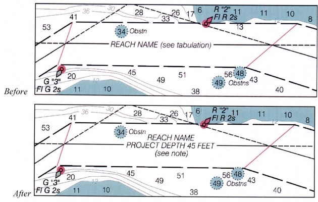
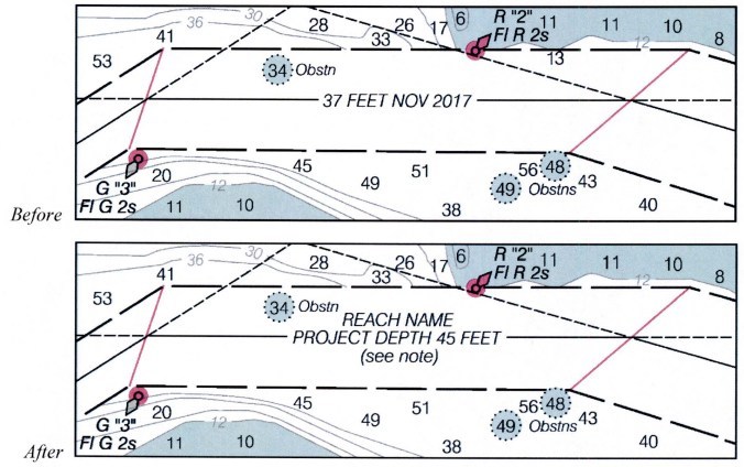
Finally, the improvement on presenting channel project depths on raster nautical chart products, such as paper nautical charts and RNCs, will provide greater clarity and safety for mariners.


