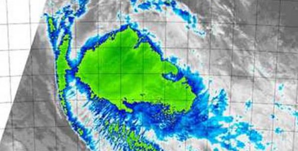
Tropical Cyclone Ola was being battered by vertical wind shear in the Southern Pacific Ocean when NASA’s Aqua satellite passed overhead and captured an infrared picture of the storm.
On Feb. 3, 2015 at 0900 UTC (4 a.m. EST), the Joint Typhoon Warning Center (JTWC) issued its final warning on Tropical Cyclone Ola. At that time, Ola’s maximum sustained winds were near 40 knots (46 mph/74 kph) and weakening. It was centered 27.4 south latitude and 161.2 east longitude, about 415 nautical miles (477.6 miles/768.6 km) southwest of Noumea, New Caledonia. Ola was moving to the south-southwest at 10 knots (11.5 mph/18.5 kph).
The Moderate Resolution Imaging Spectroradiometer or MODIS instrument aboard Aqua gathered infrared data on the storm on Feb. 3, 2015 at 13:50 UTC (8:50a.m. EST) that showed the temperatures of the cloud tops. Higher cloud tops are colder and are indicative of stronger thunderstorms. The infrared data showed that the clouds and thunderstorms were being pushed to the southeast of the center from moderate northwesterly vertical wind shear.
Forecasters at the JTWC noted that the NOAA-19 polar orbiting satellite provided a microwave image that showed diminishing convection, sheared to the southeast of a partially-exposed low-level circulation center.
The vertical wind shear is forecast to continue increasing as Ola moves into cooler sea surface temperatures. Both of those factors are expected to cause the storm to dissipate by the end of the day on Feb. 3.
Source: NASA’s Goddard Space Flight Center / Image Credit: NASA/NRL
In the origin, I was frank with you propecia before and after has changed my subsistence. It has become much more fun, and now I have to run. Just as it is improbable to sit.


