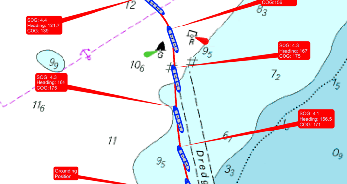
In its latest Safety Digest, UK MAIB analyzes the grounding of a ship while navigating in a narrow, buoyed channel. The incident highlighted issues associated with lack of accurate tidal stream data and poor information exchange.
The incident
While approaching a port, a large bulk carrier headed towards a narrow, 100m wide channel at a speed of 4kts with the master, second mate, a helmsman and two harbour pilots on the bridge. None of the officers had visited the port before.
The pilots had embarked immediately after piloting an outbound vessel, which had been their first pilotage act in the port. One of the pilots had the con and was navigating solely by eye.
He did not expect any difficulty with the passage or expect any tidal stream across the channel.
The tidal stream had been negligible on his outbound passage and it was now close to the predicted time of high water.
The only tidal stream information available was a tidal arrow on the paper chart indicating an easterly flood stream at a rate of 2kts.
After the vessel passed between the outer of the channel’s lateral buoys on a heading of 167º, it was set slowly to the west.
The pilot ordered the helmsman to steer 165º and requested that the engine telegraph be set to ‘dead slow ahead’.
The master advised the pilot of the vessel’s continued set towards the western side of the channel.
In response, the pilot ordered a heading of 163º. Soon after, the echo sounder alarm went off and the second officer reported that the course over the ground was 174º.
Then, the pilot ordered a heading of 157º and then steadied on 155º.
Two minutes later, the second officer advised that the speed was 4.1kts, and the pilot requested that the engine telegraph be set to ‘slow ahead’.
By that time, the bulk carrier was outside the channel and making good a course of 167º.
The vessel’s speed then slowly reduced as it took the ground in the shoaling waters near the next channel marker buoys.
The pilot tried to manoeuvre the bulk carrier towards the channel by putting the engine telegraph to ‘half ahead’ and the rudder to port.
However, the vessel remained aground on the sandy bottom. It was refloated 12 hours later with tug assistance. There was no damage and no pollution.
Lessons learned
- Harbour pilots are generally relied upon for their local knowledge, but port authority requirements vary worldwide and masters have no way of knowing or verifying pilots’ qualifications or experience. Although confidence during an initial information exchange can provide an indication of a pilot’s competence, it can also be misleading. A few polite questions in normal conversation might be more enlightening.
- Comprehensive and accurate tidal stream data does not exist for many areas and, where tidal information is charted, it can be sparse and/or unreliable depending on the source. Although the predicted times of high and low water provide an indication of tidal flow and are useful when planning, during execution the saying ‘what you see is what you get’ is relevant. The actual tidal stream experienced is what matters, and this is available through plotting on paper charts, or via the ARPA and ECDIS.
- Big ships in tight places leave little or no margin for error, and any set or drift away from an intended track must be identified and countered immediately. This is very difficult to achieve when navigating in a narrow, buoyed channel without a leading mark, radar parallel indices, or the benefit of real time positioning through an ECDIS or ECS. To delay or to ‘nibble’ can also leave a ship on the edge of a channel and the bridge team with their fingers firmly crossed.
See also:


