Industry stakeholders have discussed a lot about the pros and cons of paperless navigation concluding that ECDIS does have an edge over the traditional paper chart navigation. However, the question for the navigating officers remains the same. Can they steer the vessel, following a pre scheduled passage plan, within the safety margins that they set, from berth to berth, avoiding grounding? At this point, it is worth to mention the passage plan’s main purpose which is to use the available ‘navigational waters’ for the indented voyage so that the vessel could safely conduct the voyage.
The ‘navigational waters’ can be mainly affected by the water depth, which is indicated both on paper charts and ENCs. Specifically, the depth measurement, as indicated, is the result of a relevant depth survey which varies in age and quality depending on the measurement techniques and the available technology.
[smlsubform prepend=”GET THE SAFETY4SEA IN YOUR INBOX!” showname=false emailtxt=”” emailholder=”Enter your email address” showsubmit=true submittxt=”Submit” jsthanks=false thankyou=”Thank you for subscribing to our mailing list”]
Because priority for surveying is given to the major shipping routes, each navigator sailing into unfamiliar waters away from these routes should be able to interpret the various quality indicators that are, or should be, indicated on every chart. This is why many guides are available with best practices of navigation for commercial vessels and cruising yachts that help mariners to decide on how much confidence they should show on the marked depths. However, a mariner should be always wary of any chart that does not feature these indicators, irrespective of whether it is a traditional paper chart, or an ENC.
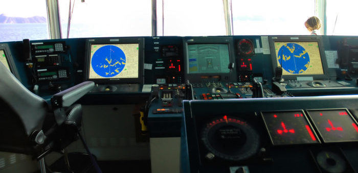
ECDIS dispay vs traditional paper charts
On the traditional paper charts, the Reliability Diagram (old charts) or Zone of Confidence diagram (new charts) indicate the depth accuracy based on surveys. Navigators should carefully check the areas that they have chosen to sail, find the relevant indication on diagram and apply additional measures or safety features to protect the vessel from grounding. On ENCs the same policy is followed with the exception of the indication of accuracy which is well spread and marked on the chart with CATZOCs (Categories of zone of confidence). The typical marks of A1, A2, B, C have now been replaced by symbol ![]() which indicates the accuracy of depth.
which indicates the accuracy of depth.
This indication is subject to ON or OFF selection by the navigator, therefore, for an unfamiliar user the risk is increasing. In particular, there is risk of not displaying and checking the depth accuracy, resulting in unpleasant situations for the passage planning, thus, vessels to reach the depth limits (in accordance with calculated UKC) and finally to run aground because the depth result was not as accurate as the navigators expected to be.
Key issues of navigational waters
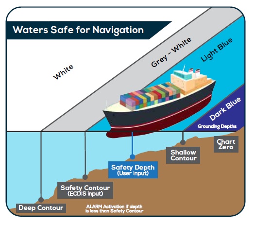
In order to prevent such situations ECDIS has by default a depth alarm system which sets the required depths for navigation. Different contours and depths indicate different parts of navigational waters. The following are some of the most common issues regarding navigational waters:
- Shallow Contour: Indicates the depth below a vessel could run aground and it is equal to vessel’s maximum static draft.
- Safety Depth = Maximum Draft(static) + UKC (Company’s Policy) + Squat(Maximum) – Height of Tide
- Safety Contour: Is calculated same as per Safety depth AND activates ALARM when depth is less
- Deep Contour: Indicates the limit of sea area where shallow water effects occur that can affect a vessel. It should be estimated twice or four times the draught of vessel (depending on the depth of water available)
ECDIS safe settings
Although color code may vary in different ECDIS system displays, the generic idea remains the same. Another key issue to consider is to include the chart depth accuracy into UKC calculation or make a comparison between the CATZOC with the UKC (Under Keel Clearance) which is more common.
The UKC sets the minimum level of distance between the deepest point of a vessel and sea bottom. In particular, it is a company-specific measurement, therefore, it is company’s responsibility to specify this distance and Masters must consider it during passage planning (especially in shallow waters).
Again, the depth accuracy emerges as an important issue for UKC calculations. For example, if a vessel has set the UKC to 0.5m but the chart accuracy has +/- 1 m, this may cause problem and the navigating officers are advised to take this issue into consideration. Table 1 shows UKC correction due to the different Zone of Confidence of ENCs.
The Category D is worse than Category C; it cannot be trusted and large anomalies in the depth can be expected. Also, the Category U is the unassessed category; the quality of the bathymetric data is not yet assessed.
In conclusion, Electronic charts and ECDIS are necessary tools for navigators in order to plan the route and monitor the position easier and faster. Considering that these electronic means are based on human surveys and measurements, the possibility of false information regarding depths, heights etc cannot be excluded. This is an additional factor to be considered during e-navigation and therefore all mariners (navigators, OOW and Masters) are advised to be always alerted and stay focused when they use these means of navigation.
[/two_third_last]

[smlsubform prepend=”GET THE SAFETY4SEA IN YOUR INBOX!” showname=false emailtxt=”” emailholder=”Enter your email address” showsubmit=true submittxt=”Submit” jsthanks=false thankyou=”Thank you for subscribing to our mailing list”]


