


Gdynia Maritime University and GPSPATRON have conducted a study regarding GNSS (Global Navigation Satellite System) interference at ground level in the Baltic Sea which can affect maritime navigation, port security, and vessel operations.
The study, was conducted from June to November 2024. The sensor used collects raw signal data, enabling comprehensive analysis of jamming, spoofing, and other anomalies affecting GNSS performance. The sensor was installed on the Faculty of Navigation building at Gdynia Maritime University in Poland, directly on the shoreline at approximately 15 meters above sea level.
As stated the primary goal of the research was to characterize the occurrence, patterns, and potential sources of GNSS interference affecting ground-level infrastructure. Unlike previous studies that relied on ADS-B data from aircraft at high altitudes, this research focused on low-altitude and ground-based disruptions.
Key findings:
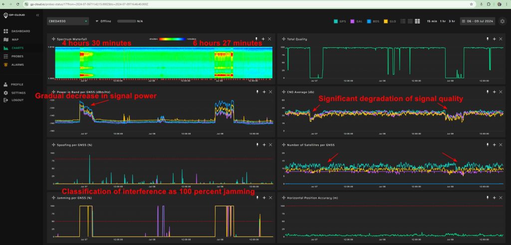
- A total of 84 hours of GNSS interference was detected, confirming persistent disruptions in the region, primarily caused by jamming rather than spoofing.
- October recorded the highest interference activity, with six major jamming incidents totaling 29 hours, highlighting an intensified interference pattern.
- Two primary interference types were identified:
- Multi-constellation jamming, detected throughout June to September, indicating broad-spectrum interference affecting multiple GNSS systems.
- Multi-tone interference, first observed in October, suggesting a change in jamming tactics, potentially signaling more sophisticated techniques.
- Long-duration interference events exceeding 7 hours were recorded, significantly disrupting GNSS-dependent maritime navigation, port operations, and infrastructure reliability.
- Severe degradation in GNSS positioning accuracy was observed during interference events, with errors increasing from the nominal 3–5 meters to over 35 meters, posing safety and operational risks.
- No correlation was found between terrestrial GNSS interference and ADS-B-based detections, reinforcing the limitations of relying solely on airborne interference monitoring systems to assess threats to ground-level infrastructure.
- Strong indications of mobile maritime jamming sources were identified, with interference signals exhibiting movement patterns consistent with vessels navigating in the Baltic Sea.
“Given the system’s radio horizon limitations and the absence of domestic interference sources within Poland, the most likely origin remains a vessel in international waters”, the research states.
The necessity of a full-scale terrestrial GNSS interference monitoring system
The findings underscore the urgent need to establish a comprehensive territorial GNSS interference monitoring network along the Baltic Sea coast. The presence of persistent and mobile jamming sources poses a significant risk to maritime navigation, port operations, and other critical GNSS-dependent infrastructure.
Given the increasing reliance on GNSS for positioning, navigation, and timing applications, the deployment of a full-scale, ground-based interference monitoring system is not just a technical necessity but also a strategic imperative.
Establishing such a network along the Baltic Sea coast would significantly enhance the resilience of regional GNSS infrastructure, ensuring uninterrupted service for maritime operations, logistics, and other essential industries that depend on precise positioning and timing data.