Our oceans are critical to so many aspects of our day-to-day lives. In the UK alone, they provide jobs for over 500,000 people, contribute more than £47 billion to the economy, and are the means through which 95% of all trade reaches the UK. Globally, people rely on the ocean for trade, food, energy and other valuable resources, as well as enabling environmental protection and international aid. Mainly, the ‘blue economy’ is estimated to be worth $3.2 trillion by the year 2030.
But how do we unlock the value of the blue economy? The key lies in accurate, comprehensive marine geospatial data.
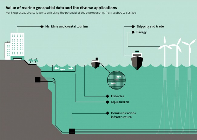
According to the UK Hydrographic office, people are relying more and more to the ocean resources, to meet the today’s changes. Therefore, there is an increasing need of getting information from the ocean, the commonly known ‘blue data’.
The blue data will help people get an insight into making the oceans smarter, more sustainable and more responsible.
Moreover, marine geospatial data can help to support a number of activities within the Blue Economy.
As the UKHO states, they are responsible for marine data great in both breadth and volume. They produce more than 15,800 Electronic Navigational Charts under their ADMIRALTY brand to support mariners internationally, as well as products to support national Defence in the UK.
The additionally hold wide-ranging data sets about the composition and nature of the marine environment, including more than 7.5 million profiles on the temperature and salinity of the ocean, 23,000 marine mammal observations, 7,000 bioluminescence observations, as well as a range of other data sets collected by ships, buoys, satellites, autonomous underwater vehicles, and more.
In the meantime, the UKHO uses its data in its Overseas territories Seabed Mapping Programme, supporting 14 UK Overseas Territories to sustainably grow their marine economies. And through the Commonwealth Marine Economies Programme, they’re helping a further 17 Commonwealth states across the Pacific and Caribbean by cooperating with their partners.
The data the office provides helps bring economic benefits to these coastal and island states, from supporting fisheries management by producing seabed habitat maps, to improving trade and tourism by supporting navigational safety at sea.


