


In addition to advantages, the use of ECDIS is accompanied by potential pitfalls
 Nobody could ever deny that electronics have provided a huge boon to the shipping industry and its safety. The comforting ability to employ satellites to provide accurate positions, regardless of weather conditions or the distance from land makes shipping more precise and far safer than it was, when a landfall after an ocean passage with no celestial observations was fraught with doubts about the accuracy of the dead reckoning.
The arrival of the electronic chart display system (ECDIS) is but the latest stage in this progression, and those who have spent hours correcting their world folios by hand are grateful for the transition. At the same time, just as every technological advance has provided misunderstandings in addition to advantages, the use of ECDIS is accompanied by snares and potential pitfalls for the unwary (and untrained).
Just as the “radar assisted” collisions demonstrated the importance of proper theoretical and practical training in the use of the new device, and every advance from ship to ship VHF communication to AIS has seen its share of accidents contributed to by improper use of the equipment, so a number of accidents have shown the need for the same application of training to ECDIS.
What might be described as a worrying trend in the use of electronic navigation systems has been exposed by the German accident investigation bureau BSU, as it probed the stranding of a German flagged heavy lift ship on a reef in the western Pacific. The course of the ship was plotted manually on a paper chart of the area, then transferred to the ship’s electronic system, and this was in use at the time of the incident.
It seems clear that what was apparent on the large paper chart effectively became invisible on the far smaller electronic projection, and a course shaped a mile off the reef somehow saw the ship stray right over the obstruction. The cause of the stranding was attributed to “transcription errors”, but it is probably true to suggest that it would not have happened had the new device not have been employed, and if the vessel was being navigated on paper charts.
This is by no means the first accident of its kind, and the problems seem to be twofold. First, there is the fact that if the small electronic screen is not to be cluttered, much of the information contained on the larger paper version must be “edited out”. Accidents have occurred when this “editing” has included something vital, such as a buoy or beacon, a coloured marking indicating a shoal, or some other vital navigational “need to know” information. Unfamiliarity with the equipment supplied aboard a particular ship and inadequate type-specific training have been blamed for such problems.
On certain and even more disastrous occasions, it has been whole remote reefs and tiny islands that have become invisible in the electronic chart version being used by the ship, which has come to a grinding halt where the electronic chart showed no hazard in the vicinity.
Secondly, the scale of the chart shown on a screen no bigger than the size of the average desktop computer seems to militate against the best possible use of this important and useful aid to navigation. Some professionals have suggested that the “miniaturisation” of the chart in electronic form is self-defeating, and if it is possible to manufacture the large screens which TV manufacturers are anxious to sell, it should be perfectly possible to provide an ECDIS screen effectively the same size as the paper chart. You learn, it is said, by “trial and error”. The trouble is that with shipping, our errors tend to be expensive!
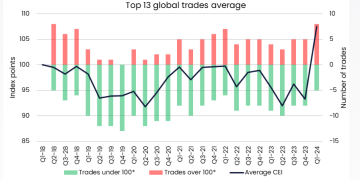
Source: BIMCO, Watchkeeper