


IPCC review on climate change
it is extremely likely (95-100% probability) that most of the warming since 1950 has been due to human influence.
Read more


it is extremely likely (95-100% probability) that most of the warming since 1950 has been due to human influence.
Read moreNASA s IceBridge Seeking New View of Changing Sea Ice
Read moreSatellites see Unprecedented Greenland Ice Sheet M
Read moreNASA's stunning Perpetual Ocean animation visualizes ocean currents The animation nicely highlights the energetic turbulent ocean surface currents that are present in the real ocean but are not directly visible to the eye. Numerous people have also remarked that the visualization evokes the Starry Night by Vincent van Gogh.
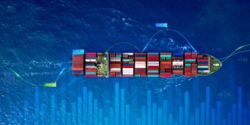
Read moreNASA, ESA to monitoring global maritime traffic As the International Space Station circles Earth, it has been tracking individual ships crossing the seas beneath. An investigation hosted by the European Space Agency (ESA) in its Columbus module has been testing the viability of monitoring global maritime traffic from the station's orbit hundreds of miles (kilometers) above since June 2010.The ship-detection system being tested is based on the Automatic Identification System, or AIS, the marine equivalent of the air traffic control system.All international vessels, cargo ships above certain weights and passenger carriers of all sizes must carry "Class A" AIS transponders, broadcasting continually updated data, such as identity, position, course, speed, ship particulars, cargo and voyage information to and from other vessels and shore.AIS allows port authorities and coast guards to track seagoing traffic, but the system relies on VHF radio signals with a horizontal range of just 40 nautical miles (74 km). This makes it useful within coastal zones and on a ship-to-ship basis, but not in the open ocean; ocean traffic was largely untracked. However, AIS signals travel much further vertically, making the space station an ideal location for space-based AIS signal reception and, therefore, providing the capability of ...
Read moreDrastic reductions in Arctic sea ice in the last decade Drastic reductions in Arctic sea ice in the last decade may be intensifying the chemical release of bromine into the atmosphere, resulting in ground-level ozone depletion and the deposit of toxic mercury in the Arctic, according to a new NASA-led study.The connection between changes in the Arctic Ocean's ice cover and bromine chemical processes is determined by the interaction between the salt in sea ice, frigid temperatures and sunlight. When these mix, the salty ice releases bromine into the air and starts a cascade of chemical reactions called a "bromine explosion." These reactions rapidly create more molecules of bromine monoxide in the atmosphere. Bromine then reacts with a gaseous form of mercury, turning it into a pollutant that falls to Earth's surface.Bromine also can remove ozone from the lowest layer of the atmosphere, the troposphere. Despite ozone's beneficial role blocking harmful radiation in the stratosphere, ozone is a pollutant in the ground-level troposphere.A team from the United States, Canada, Germany, and the United Kingdom, led by Son Nghiem of NASA's Jet Propulsion Laboratory in Pasadena, Calif., produced the study, which has been accepted for publication in the Journal of Geophysical ...
Read moreNASA's MODIS satellite instrument reveals how air pollution may alter clouds
Read moreNASA's Operation IceBridge discovered a major rift in western Antarctica In October, 2011, NASA's Operation IceBridge discovered a major rift in the Pine Island Glacier in western Antarctica. This crack, which extends at least 18 miles and is 50 meters deep, could produce an iceberg more than 800 square kilometers in size. IceBridge scientists returned soon after to make the first-ever detailed airborne measurements of a major iceberg calving in progress.
Read moreFirst global map of the salinity of the ocean surface NASA's new Aquarius instrument has produced its first global map of the salinity of the ocean surface, providing an early glimpse of the mission's anticipated discoveries.Aquarius, which is aboard the Aquarius/SAC-D (Satélite de Aplicaciones Científicas) observatory, is making NASA's first space observations of ocean surface salinity variations -- a key component of Earth's climate. Salinity changes are linked to the cycling of freshwater around the planet and influence ocean circulation."Aquarius' salinity data are showing much higher quality than we expected to see this early in the mission," said Aquarius Principal Investigator Gary Lagerloef of Earth & Space Research in Seattle. "Aquarius soon will allow scientists to explore the connections between global rainfall, ocean currents and climate variations."The new map, which shows a tapestry of salinity patterns, demonstrates Aquarius' ability to detect large-scale salinity distribution features clearly and with sharp contrast. The map is a composite of the data since Aquarius became operational on Aug. 25. The mission was launched June 10 from Vandenberg Air Force Base in California. Aquarius/SAC-D is a collaboration between NASA and Argentina's space agency, Comisión Nacional de Actividades Espaciales (CONAE)."Aquarius/SAC-D already is advancing our understanding of ...
Read moreThere were four tropical cyclones or remnants plaguing the Atlantic Ocean There were four tropical cyclones or remnants plaguing the Atlantic Ocean basin on Sept. 8, 2011, and one satellite captured all four in one image: Katia, Lee, Maria and Nate.NOAA's GOES-13 satellite monitors the Atlantic and eastern U.S. and took a stunning image of Hurricane Katia in the western Atlantic between Bermuda and the U.S. East coast; Tropical Storm Lee's remnants affecting the northeastern U.S.; Tropical Storm Maria in the central Atlantic; and newborn Tropical Storm Nate in the Bay of Campeche, Gulf of Mexico. The visible image was created by the NASA GOES Project at NASA's Goddard Space Flight Center, Greenbelt, Md.Hurricane Katia Hurricane Katia is causing rough surf along the U.S. east coast, and fortunately that's all she'll do. On Sept. 8, 2011, her center is passing between Bermuda and the east coast of the U.S. Bermuda is still under a tropical storm watch. Katia's eye is still visible in this GOES-13 image.NASA's Aqua satellite's AIRS instrument measured the cloud top temperatures within Hurricane Katia on Sept. 8 at 2:29 a.m. EDT. The infrared data showed the coldest cloud top temperatures (-63F/-52C) and strongest thunderstorms with the ...
Read more