


The Panama Maritime Authority informed about the recent amendment of the High Risk Area (HRA) description in Section 2 of BMP4, which is effective from 1st December 2015.
For the purpose of BMP the High Risk Area is an area bounded by:
- In the Red Sea northern limit Latitude 15° N
- In the Gulf of Oman northern limit Latitude 22° N
- Eastern limit: Longitude 065° E
- Southern Limit: Latitude 5° S
The current HRA should be reduced in area to reflect the recent experience of ships in the Indian Ocean, as well as available data provided by military headquarters.
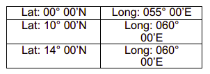
Starting on May 1st, 2019, the new coordinates of the HRA are:
-In the Indian Ocean a line linking from the territorial waters offs the coast of East Africa at Latitude 05° 00’S to 050°00’E:
-Then to positions:
Taking in consideration the last incidents reports of the Panamanian flagged vessels, the following areas are considered to continue to suffer attacks and robberies. Given the aforementioned, this Administration will also consider the following, as High Risk Areas:
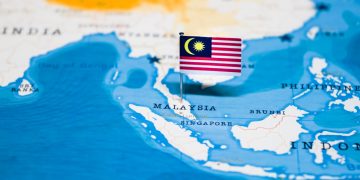
-S.E. ASIA AND THE INDIAN SUBCONTINENT
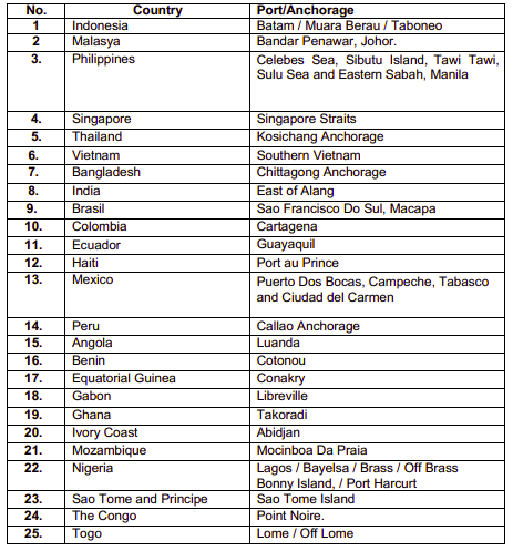
- Indonesia: Belawan, Dumai, Karimun Kecil/Besar, Pulau Nipah, Pulau Takong Kecil, Jakarta /Tanjung Priok, Muara Berau, Pulau Bintan, Batam and Taboneo.
- Malacca Strait
- Malaysia: Tanjung Piai, Bandar Penawar and Johor.
- Philippines: Celebes Sea, Sibutu Island, Tawi Tawi, Sulu Sea and Eastern Sabah. S.E.
- Singapore Straits
- Thailand
- South China Sea
- Vietnam: Vung Tau
- Bangladesh: Chittagong, kutubdia and Chittagong Anchorage.
- India: Kandla, Kochi, Visakhapatnam and East of Alang.
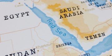
-AFRICA AND RED SEA
- Somalia waters: Eastern and Northeastern Coast.
- Ghana: Takoradi
- Angola: Luanda
- Guinea: Gulf of Guinea, Conakry
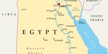
- Egypt
- Benin: Cotonou
- Gulf of Aden
- Gabon: Libreville
- Ivory Coast: Abidjan
- Sierra Leone
- Kenya
- Liberia
- Mozambique: Mocinboa Da Praia
- Nigeria: Lagos / Bayelsa / Brass / Bonny Island / Port Harcurt
- Red Sea
- Congo: Pointe Noire and Northern Somali Coast in the Gulf of Aden and Southern Red Sea in The Bab El Mandeb
- Togo: Lome
- Sao Tome and Principe: Sao Tome Island
-SOUTH, CENTRAL AMERICA AND THE CARIBBEAN WATERS
- Colombia: Cartagena
- Haiti: Port Au Prince
- Jamaica
- Venezuela: Puerto Jose, Puerto La Cruz
- Brazil: Macapa and Sau Francisco Do Sul Guyana
- Peru: Callao Anchorage
- Dominican Republic Ports
- Ecuadorian Ports
- Mexico: Gulf of Mexico, Gulf of Campeche, Tabasco, Puerto Dos Bocas
Incidents in 2020
In 2020, a high number of incidents (attempt of boarding, boarding and robbery) were reported in the below listed ports and anchorages.
This is why the Panama Maritime Authority encourages to all the Ship-owners/Operators and Masters to take the proper maritime security measurements in order to reduce and deter the risks associated.
Preventive measures
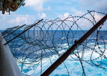
- MMC-195 and 197 states that all Panamanian flagged vessels, under SOLAS V/19-1 regulations must comply with LRIT requirement. The LRIT System must work properly as the ships are transiting High Risk Areas. This ensures the possibility to track vessels and will allow detecting any unexpected change of course or any other suspicious situation.
- The Panama Maritime Authority encourages all our Ship-owners/Operators, Company Security Officers, Legal Representatives of Panamanian Flagged Vessels to have as a First Option, the use of the Best Management Practices (BMP), and the Internationally Recommended Transit Corridor (IRTC); MMC No.208.
- All Panamanian flagged vessels are requested prior to transit, or leaving a port within the region, to follow the latest BMP and to contact the local information centers for up to date instructions or transit and reporting.
- The use of PCASP should not be considered as an alternative to BMP and other protective measures. It is recommended that BMP be applied.
- Recommended Transit Corridor (IRTC) and be considered as the first, minimum, preventative option. Placing armed guards on board as a means to secure and protect the ship and its crew should only be considered after a risk assessment has been carried out.
- Panama flagged vessels operating within the World Food Program in the Gulf of Aden (GoA) and Somali Basin shall implement as far practicable the BMP.
- The incidents of vessels transiting the Celebes – Sulu Seas continue to be reported to the IMB Piracy reporting Centre. Most incidents are targeted towards vessels approaching / entering the Sibutu Channel, which is probably the only safe and navigable channel joining the Celebes Sea to the Sulu Sea. This Channel is also the shortest, north/south route from and to Australia and the Southern Indonesian Islands. The vessels targeted are; bulk carriers, general cargo ships, fishing vessels, tankers and tugs and barges – all of which do not have excessive speed capabilities or freeboards when loaded.
To reduce the risk, the IMB is advising owners and charterers to consider the recommendations in IMO circular 1334 as well as the Risk Assessment and vessel hardening procedures given in the BMP. Depending on the risk assessment, consideration could be given to routeing west of Kalimantan and straight into the South China Sea thus avoiding the Celebes / Sulu Sea all together. The IMB appreciates that this will increases sailing time and thus costs, but we recommend this as a possible safer route.
- All Panamanian flagged vessels transiting in the Gulf of Guinea must to remain at least 250 NM from the coast at all times, or until the vessel can transit to commence cargo operations at a berth or safe anchorage.
- The Panama Maritime Authority encourage all Operators, CSO and Owners of Panamanian flag vessels, to contact the IMB Piracy Reporting Center 24/7, in case of any incident of piracy or armed robbery that occurs in any part of the country world. The information received is important in order to be able to alert the response agencies in the region to take action as well as raise awareness for other ships in the vicinity by broadcasting via Inmarsat Safety Net Service.
Explore more herebelow: